Showing posts with label Himalayas. Show all posts

Sunday, January 20, 2013

HIKING (AND CLEANING UP) THE INDIAN HIMALAYAS

Our friend Alex Parlini (the dark speck on the trail) hikes toward Kanchenjunga, the world's third highest peak.
While Liz headed south to Udaipur, Mumbai, and Goa, Kip and his buddy Alex from DC went northeast to Darjeeling (thanks for the visit, AP!). After testing out the region's famous teas, they traveled into the Indian Himalayas for a trek toward the world's third highest peak, Mt. Kanchenjunga (alt: 28,169 ft)

There, they hiked five days and watched some incredible sunsets/rises over the mountains of India/Tibet/Nepal/Bangladesh/Bhutan, one of the most unique and spectacular views in the world. 

Along the way, they also filled garbage bags with trash that lined the trails. As we had experienced in places including Nepal, Borneo, the Philippines, and others, the people met along the way happily joined the trail beautification efforts, proving once again that cleaning up...and volunteering...can be contagious. A big thanks to the guides, as well as Alex, Stewart, Stephanie, Raymond, and Sara.
With no trash collection in the mountains, garbage must be burned to get rid of it. Above, Alex supervises while the guides incinerate a small pile of some of the debris we collected during the five-day hike.
Mt Kanchenjunga in the morning light.
Kip at sunrise. The view includes Everest.

Potato diggers met along the trail.


The sun sets behind afternoon clouds.

Tuesday, November 13, 2012

CLOUDS SWALLOW THE HIMALAYAS

Watch clouds engulf Lobuche's 20,000-ft peak.

The Himalayas tower far above everything. Even clouds often struggle to reach the summits of the world's tallest mountains. 

Yet, in the right conditions, a quick-moving storm can engulf the highest of Himalayas in a matter of seconds, as seen in the time lapse series of images above.

One of the images from the time lapse video showing Lobuche 
It was sometime before midnight on a blustery night two days' trek from Everest Base Camp. Bundled in all our clothes, we hiked a few minutes from camp to check out the stars before bedtime. Here above 16,000 feet, the wind chill was near zero. The cold, thin air made breathing difficult. 

After watching a cloud bank crawl slowly through a nearby valley, we set up the camera to try out time-lapse photography. Every 30 seconds for 15 minutes, we took a photo of the scene above, as clouds engulfed a pair of 20,000+ peaks before our eyes. 

Pros typically use a tripod and a remote control for time lapse shots...we used a pile of rocks, a wool hat, and a frost-bitten finger. The results, while not exactly pro-quality, we felt were worth posting anyway.

Hope you enjoy.

If you like this one, here are a few others (taken by pros) that are way better: time lapse nature photography

Tuesday, November 6, 2012

WORLD'S MOST DANGEROUS FLIGHT

The 15,000-foot view from our flight to Lukla, Nepal, home of the world's most dangerous airport.
If you want to trek to Everest Base Camp in Nepal, chances are you'll be flying into Lukla's Tenzing-Hilary Airport. Deemed "the most dangerous airport in the world" the airport sits at nearly 10,000 feet, features a single runway less than 1,500 feet long (most commercial runways are more than 5,000 feet) and is built on a 12 percent slope that on one end collides with solid rock and the other falls off steeply into a deep valley. 

It's not exactly leisure travel, but considering the alternative was taking a rickety bus for 10 hours along dangerous mountain curves, followed by four days of hiking uphill, we decided to take our chances. 

A twin-prop plane preps for the downhill take-off from Lukla's airport at 9,100 feet.
However, before we could defy death by landing at the airport, we first had to survive an hour-long, knuckle-whitening flight from Kathmandu to get here. This is the same flight that crashed in late September this year, killing all on board.

Nervous would be an understatement. 

From our seats in the well-used, twin-prop plane, we did see some stunning views of Mt. Everest. Yet we also got unwanted pilot's-eye views through the cockpit, where the captain and co-pilot wove skillfully between swirling storm clouds, dodged soaring vultures, and let the wings skim dangerously close to the peaks of some of the world's highest mountains.

On our flight, one person cried, two passengers hurled, and three on-board screamed out loud when we hit turbulence on our approach to Lukla. We'll let you guess which of us was included in the aforementioned stats.

Upon landing (and kissing the asphalt runway much too intimately), we grabbed our heavy backpacks and headed quickly up the dirt and stone trail into Lukla. In addition to the flight, we had been awake since 5 am, and we had six hours of uphill hiking ahead. We needed a drink.

Our celebratory coffee on making it to Lukla alive and kicking-off the long trek to Base Camp.
Thanks for the drink, readers!
Considering we hadn't yet had breakfast, we opted for two strong Everest coffees and some fresh apple strudel from a nearby bakery (thanks for the contributions, readers Todd and Tori P, Alison J, Ben P, and Lindsay N!)

With our caffeine fix and some time to calm our nerves, we headed up the trail, starting a 12-day return trek to Everest Base Camp. Seeing as Kip refused to buy a map or hire a guide or porter, we'll need all the luck we can get. 

The son of the bakery owner gives us the thumbs up as we hit the trail to Everest Base Camp.

Sunday, November 4, 2012

PLAINS AND MOUNTAINS ON THE TIBETAN PLATEAU


On the downhill run from Lhasa into Nepal, roads are lined with arid plains dotted with goats, cows, miles of barley, and the ruins of thousand-year old structures that are slowly melting back into the earth (see two "mounds" in the middle right). The golden fields stretch for miles until they collide with rolling hills that morph slowly into mid-size mountain ranges--in a land where 18,000-foot peaks are "mid-size"--and finally, into the Himalayas. 

It only took us eight days, but we finally got a decent photo that included Mt. Everest (at least, our guide assured us the peak in the background is the highest one in the world). 

On toward Nepal and a trek to Mt. Everest Base Camp. We hope.

Friday, November 2, 2012

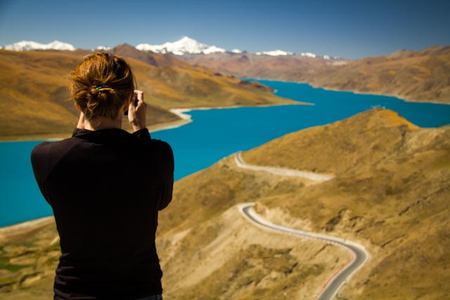
PHOTO FRIDAY: BLUEST LAKE IN ASIA


It's hard to believe the color of Tibet's Yamdrok Lake is natural. But it is. 

The sacred, sapphire-blue water appears exactly as the photo above was taken...no touch ups or highlights added or needed. After this quick stop for pictures and some Himalayan views, we drove down the winding road to the lake's edge, where Liz, naturally, took off her flip flops and ventured into the chilly waters. 

At 14,470 feet (4,410 m), the lake is one of Tibet's highest and largest. The Yamdrok is also, according to local legend, a female guardian of Buddhism, and its shores trace the outline of a scorpion. No idea if the two are related. 

Friday, October 26, 2012

PHOTO FRIDAY: STARRY NIGHT IN TIBET


Above, a night view of Mt. Cho Oyu (26,906 feet) and the Himalayas from a frontier town in southern Tibet called Tingri. 

We'd like to say the summit you're seeing is Mt. Everest, which is clearly visible from where this photo was shot. However, in a typical moment of Liz & Kip travel brilliance, we realized at 4 am in the freezing cold on a tiny bridge just outside of town, that we didn't know which of the surrounding snow-capped peaks was the largest in the world.

Sadly, the world's highest mountain is about half-an-inch beyond the left edge of the frame of this shot. 

It looked real nice. Really, it did.

Yes, after six months, we're still the clueless travelers we were when we started.